


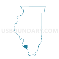
CHESTER 6 Voting District, Randolph County, Illinois
About
Outline

Summary
| Unique Area Identifier | 574073 |
| Name | CHESTER 6 Voting District |
| County | Randolph County |
| State | Illinois |
| Area (square miles) | 5.77 |
| Land Area (square miles) | 5.76 |
| Water Area (square miles) | 0.01 |
| % of Land Area | 99.88 |
| % of Water Area | 0.12 |
| Latitude of the Internal Point | 37.94041510 |
| Longtitude of the Internal Point | -89.77699940 |
Maps


Graphs
Select a template below for downloading or customizing gragh for CHESTER 6 Voting District, Randolph County, Illinois


Neighbors
Neighoring Voting District (by Name) Neighboring Voting District on the Map
- BREMEN Voting District, Randolph County, IL
- CHESTER 4 Voting District, Randolph County, IL
- CHESTER 7 Voting District, Randolph County, IL
- PALESTINE Voting District, Randolph County, IL
Top 10 Neighboring County Subdivision (by Population) Neighboring County Subdivision on the Map
- Chester precinct, Randolph County, IL (9,314)
- Palestine precinct, Randolph County, IL (601)
- Bremen precinct, Randolph County, IL (443)